Sunday’s Travels, Revisited with Pictures, Part 6: Hilo

We got down to Hilo about 5:30pm, and guess which cruise ship was sitting in port.. Hey Steve, it’s the "Pride of America" for the third time! We seem to be following each other around the islands the past few days….

hilo1

hilo2

Then we saw the statue of King Kamehameha the Great in Hilo before we decided to grab a pizza at Pizza Hut for dinner and then make the 1h 45m trip back to the hotel. There are still 2 waterfalls in the Hilo area we would like to see, if we get the chance….

We would like to get back down to Hilo to tour the Mauna Loa Macadamia Nut factory/plantation as well.

On Monday, we are planning a drive down the desolate west and south shores, to the black sands beach and other sights….

Sunday’s Travels, Revisited with Pictures, Part 5: Flora at Akaka Falls

Some Pictures of the Flora we found on our walk to Akaka Falls

flora1

flora2

flora3

flora4

flora6

This last one was on someone’s property on the road to Akaka Falls. We took the picture on the way back to the Island Loop Road.

Sunday’s Travels, Revisited with Pictures, Part 4: Akaka Falls

We drove down the east shore, all the way to Hilo, stopping at Akaka Falls on the way down.

akaka1

We made the hike down to Akaka Falls, but it was a big climb back to this sign, so the hike to Kahuna Falls was declined, since many people said you did not get a good look at the falls from the viewpoint, anyway.

akaka3

No, this is not Akaka Falls, it is one of the streams we crossed on the way to the falls, though, and it had a nice set of cascades, two here and one directly under the bridge.

akaka4

akaka5

Close up views of the two small falls above the footbridge to Akaka Falls.

akaka7

This is Akaka Falls, 760 feet top to bottom. If you look at the top banner picture on the blog, you will see a picture of this falls on the left side as well. I think I like mine better 8-)

akaka8

This is the plunge pool at Akaka Falls, anyone for high diving??

Sunday’s Travels, Revisited with Pictures, Part 3: Waimea & Mauna Kea

As we descended into Waimea, we came upon our next natural disaster of the trip… another fire. This one was only a small grass fire, only a few acres, probably less than 100, anyway.

waimea1

It was still smoldering, but it was 100% contained, and the fire department was letting it burn itself out by this point.

waimea2

waimea3

Marianne had to take this picture. It was strange to see the cactus and fir trees side by side.

waimea4

Sheep grazing on the hills, most likely part of the Parker Ranch, the largest and oldest ranch on Hawaii.

maunakea3

It was a beautifully clear day in Waimea, and we could see all the way to the
top of Mauna Kea and see the observatory domes where our friend Tom works a few
times a year. Would love to go up there, but I don’t thing our health conditions
are good enough for the 13,789 foot elevation…

Sunday’s Travels, Revisited with Pictures, Part 2: Kohala Mountain Road

We headed north out of the resort, and then took the loop road around the northern point of the island. The western outbound road stays at a lower elevation along the coastline and is dry, desert like climate, with dry grass and scrub brush, typical of the leeward side of all the islands.

The return road travels along the ridge line or slightly west of it, at an elevation up to 3700 feet, and you are only a couple miles north of the outbound road along the coast. There are terrific views of the Waikoloa Bay and Kohala Coast area where the resort is located. After we got back down to the Hawaii Loop Highway, we continued easterly around the island.

kohala1

This is a view of multiple ancient vent cones on the Kohala Mountain Road, looking ESE.

kohala2

This is a look westward from the Kohala Mountain Road, down towards the ocean. You can see the green turns to brown fairly quickly as you drop down the slope. We are currently about 3,000 feet high, and only about 4 miles from the ocean.

kohala3

A closer look at one of the ancient vent craters.

kohala4

Looking down the dry landscape towards the Kohala Coast and Waikoloa.

kohala5

Another view towards the ocean and the upper Kohala Coast.

kohala6

A view down the ridge from 3,500 feet towards the resort area of the Kohala Coast.

kohala7

A more close-up view of what may be our resort, but we are not sure of the exact location from this distance. The Hilton Waikoloa Village Resort may be closer to the top of the first picture.

kohala8

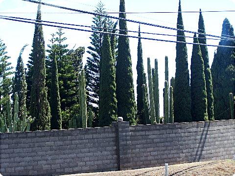
As we descended the ridge towards Waimea, we found the hillsides covered with cactus plants!

kohala9

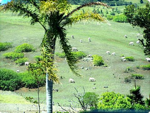
More cactus, along with farms and the extremely dry western side landscape that is found on all the islands….